Letter from Hawke’s Bay Regional Council
We have reproduced below Bay of Plenty Regional Council's letter to us. We have not carried out any auditing or other work to test the veracity of the information provided.
14 April 2022
Leeanne McAviney
Assistant Auditor General
100 Molesworth Street
Thorndon
WELLINGTON 6011
Tēnā koe Leeanne
FOLLOWING UP ON PERFORMANCE AUDIT OF MONITORING HOW WATER IS USED FOR IRRIGATION – REPORT PUBLISHED MAY 2018
Thank you for your letter of 11 March requesting information from Hawke’s Bay Regional Council (Council) on how Council is addressing the monitoring of water use for irrigation in the region. You have asked how Council has addressed the recommendations of the Audit Report published in May 2018. In response, we have prepared a report, enclosed with this letter.
Council has a programme in place to ensure water takes are measured, that the methods used are reliable and accurate, and that the data is received and made use of. In carrying out this work, Council is working with consent holders and data service providers on a regular basis. The data that is provided is being used to inform decision making to enable effective and efficient use and management of the regions water resources.
Council has undertaken significant Plan changes in 2015 and 2019 reviewing allocation limits for rivers and developing them in groundwater catchments that have previously not had them. Allocation limits for ground and surface water takes have been implemented in the 2019 proposed plan change for the Tutaekuri, Ahuriri, Ngaruroro and Karamu Catchments (TANK). The limits set in the proposed TANK plan is the policy response to the over-allocation of the Heretaunga Plains groundwater resource. This overallocation is evident in the effect current groundwater takes are having on connected surface waters. Also from the measurement of water use it is evident that more water could be taken because, on paper, existing permits allow for greater amounts of water to be taken than is actually required. Strategies are also included in the TANK plan for new water opportunities and development of flow augmentation solutions.
Efficient management of freshwater resources is supported by the development of surface water and groundwater models. These will be at the core of the review of our planning provisions as we embark on the development of a new Regional Resource Management Plan (RRMP) that will encompass the Regional Policy Statement and the Coastal Plan. The new RRMP is known as Kotahi.
In addition, Council has established and is working with Catchment groups. Working with these groups Council can inform communities of the resource availability and limitations and to assist with strategies to make best use of the water that is available. Council is sharing and promoting more information with the public about the quantity and quality of the freshwater resource in the region. In doing so, Council are establishing a water allocation tool to concisely count the amount of water that is allocated from each water management area. This is to be made available online to anyone who wants to apply for consent or has a consent that will require review and renewal or for the community at large.
Council is carrying out its duties in this area responsibly, effectively and constructively and considers that our approach accords with the recommendations and opportunities identified in the Auditor General’s 2018 report.
Nāku noa, nā
James Palmer
Chief Executive
Phone: 835 9200
Email: [email protected]
FOLLOW UP ON PERFORMANCE AUDIT OF MONITORING HOW WATER IS USED FOR IRRIGATION – REPORT PUBLISHED MAY 2018
Introduction
The Auditor General (AG) has written to the Hawke’s Bay Regional Council (Council) asking that Council report on its work in measuring irrigation water use in light of AG audit report published in 2018. In particular the AG has asked that the response
- outlines how your organisation has used the results of the performance audit and the impact our findings have had;
- describes the action(s) that your organisation has taken to address each of the recommendations;
- describes how you know those actions will be effective in addressing the concerns behind each of the recommendations, and lead to lasting improvement; and
- provides examples of the impact any improvements are having, including how they are affecting, or experienced by members of the public accessing and using services.
Council has a programme in place to ensure water takes are measured, that the methods used are reliable and accurate, and that the data is received and made use of. The AG report has not been the reason for this programme but it reinforces the appropriateness of what this Council is doing. In carrying this out Council is working with consent holders and data service providers on a regular basis. The data that is provided is being used to inform decision making to enable effective and efficient use and management of the region’s water resources.
WATER INFORMATION SERVICE
Council, and particularly the Water Information Services team, has worked with consent holders and data service providers to improve the timeliness and completeness of water-use data received. There are approximately 2529 operational water meters, of which 2110 are fixed meters and 419 are on portable pumps.
There are processes in place at Council to track new consents, changes of consent holders and changes of conditions. A report is generated each week from IRIS (consent database management system) and this tracks any changes. Water Information Services (WIS) then contact the consent holder outlining the conditions that need to be met. This can involve setting them up to use the Council WIS website to enter readings and adding them to an email list so that reminders can be sent out. It can involve outlining meters and telemetry that need to be installed and when this needs to be done by. WIS use IRIS to set up tasks to check that the consent holders have fulfilled all the water take measuring and reporting conditions in the consents.
To ensure that water meter readings that are entered by the consent holders are up to date, emails are generated once a month over the summer season for reminders and in June and July for the annual returns. To track that data is up to date we also have purpose built software that can run timeliness checks and consent holders are contacted if they are late with returning data. If this becomes more of a problem it is passed to our Compliance section to action. We have found that the number of consent holders who are late returning data has greatly reduced over the past five years. This has come about for of a number of reasons. When water meters were first introduced there was a fear that consent holders would find that they were non-compliant. Once they realised they were within their consent conditions they were much happier to supply the readings. For many it has become a habit and they do the readings the same time each week. Another reason for those who live on the Heretaunga Plains is the TANK policy that has been published. They are wary of having their consented volumes cut back and this means they are very keen for Council to have a record of their water use.
Other consent holders have chosen to install telemetry so they do not have to remember their water meter readings. In 2016 430 consents were monitored by telemetry and now there are 920 consents a 53% increase.
There has been a steady increase in the last nine months after notification of affected consent holders of the changes to the Measuring and Reporting of Water Takes Regulations 2021. Annual audit meter readings are required so that we can check that the telemetry data we are receiving is complete. The required forms for meter installations and verifications also provide a good cross reference for checking telemetry. Telemetry data first started coming in in 2011 so we have some long term sites.
Good relationships have been established with all data service providers in Hawke’s Bay. There are only a limited amount of data providers as only those who can demonstrate that they can provide a reliable service and can fix any problems in a timely manner are deemed ‘Blue Tick’ providers and given access to our FTP site to deliver data to Council. This way we track all new installations, set up alarms for late data and send notifications to the service providers of data that is late.
The majority of our telemetry data comes in through the eight data service providers who are Blue Tick accredited for Council. The exceptions are very large industrial companies who have their own Scada systems and software engineers who can set up a daily data transfer to Council. These are companies like Trustpower, Pan Pac and Ravensdown. Good working relationships have also been established with these companies so that complete water use data is being received.
Council have purpose built software to help keep a track of water meter installations, verifications and re-verifications. A Technical Advisor is employed to work with the Service Providers to ensure that meter installations are all to the required standards. The Technical Advisor also works with the verifiers to ensure that they are operating to the New Zealand Measurement Code of Practice and that any new verifiers are also operating to these standards before we accept them as a verifier in Hawke’s Bay.
Our ‘Verification’ software helps us to keep a track of verifications that are due and those that have been completed. It sends email reminders and accepts the new results and binds into our database for tracking water take consents. We can keep a track of how many notifications need to be sent out each month and prepare emails for these. By making sure that verifications are being done after five years, we are seeing the replacement of under-performing water meters and thus ensuring that water use records will be as accurate as possible.
The Compliance team works closely with the Water Information Services team, especially with the following up of rate of take or allocated volume exceedances, overdue meter verifications or non-reporting of meter readings.
Water use is monitored in real time to ensure that rates and volume limits are not exceeded. A weekly report on all water exceedances is generated and the compliance team will engage with consent holders found to be exceeding their entitlements and seek an explanation. Exceedances can be to the instantaneous rate of take, weekly or 28 day volumes and annual volumes.
The initial approach taken is education, and the team will work closely with consent holders to help them comply. This may include explaining their relevant consent conditions to advising of phone apps that can send alarms or provide live data to cell phones of their water usage.
For any non or overdue meter verifications, the consent holder is given a timeframe to have the verification completed.
If the non-compliance continues or reoccurs, enforcement action is undertaken, starting with a formal warning, then progressing to the issuing of an abatement notice and or infringement. Any serious non-compliance may lead to prosecution.
The Compliance team regularly visits properties for a variety of consent inspections. For the last year, they have had access to an online form on their tablet where they can and enter water meter readings for a particular consent. These audit readings are received by the Water Information Service team, who input the reading into the system and will check for any irregularities or non-compliance.
PROCESS CHANGES
The Ministry for the Environment amended the Resource Management (Measurement and Reporting of Water Takes) Regulations 2010 (commencing on 3 September 2020) to require electronic reporting (Reg 7A) and to require verification of device or system accuracy (Reg 8A). These are to be phased in over the next 6 years by Councils. Council has required telemetry for all surface water takes since 2006 (to enable demonstration of compliance with flow restrictions). Council has also been requiring telemetry for new and replacement groundwater takes and will ensure that this is provided in line with the updated Regulations, if not before.
Council has worked to ensure data is accurate. We had realised that there were installation and calibration issues with the initial installations of water meters and telemetry. Council has standard conditions addressing the verification of device and system accuracy. These have been updated since the AG’s report. The conditions are set out below.
- A water meter with a data logger and a telemetry unit(s) compatible with the Council’s telemetry system shall be installed prior to the exercise of this consent and be operated and maintained to measure the volume of water taken to an accuracy of +/- 5%.
- Water take and use data supplied to Council in accordance with conditions of this consent shall be collected by a water measuring device or system that has been verified by a suitably qualified person to be accurate to within +/-5% at that point of take within the following time periods:
a) For existing devices or systems: within the previous 5 water years (water year is 1 July - 30 June); or,
b) For new devices or systems: before the end of the first water year (ending 30 June) for that water permit. - All water measuring devices or systems shall be re-verified by a suitably qualified person as accurate to within +/-5% within a maximum of 5 years from the date of the previous verification.
- Where a portable pump is used to take water as authorised by this consent, both the water meter and telemetry devices must be installed, operated and maintained in accordance with the Council’s Technical Publication "Council’s Requirements for the use of Portable pumps used to report water use" (February 2013) (see Advice Note II).
- The telemetry unit(s) shall record the rate and volume of take every 15 minutes. Each 15 minute interval of data shall be date and time stamped with the New Zealand Standard Time at the end of the 15 minute interval.
- Data shall be transmitted to the Council’s telemetry system at least once per day.
- The telemetry unit(s) shall be installed so as to provide an accurate record of the flow meter data by a suitably qualified person. A record of installation shall be provided to the Council (Manager Compliance) in writing using the Council’s “Telemetry Installation Form” within one week of installation of the new or reinstalled unit(s) having occurred (see Advice Note II).
The Regional Resources Management Plan (RRMP) has set allocation limits for rivers (operative 2006) and Plan Changes 6 (operative October 2015) and 9 (proposed, notified May 2019) have reviewed and developed these in the Tukituki Catchment and Heretaunga Plains (TANK) respectively since then. The TANK proposed plan has developed allocation limits for ground and surface water resources. These limits reflect that there is an over-allocation of the Heretaunga Plains groundwater resource (both in terms of the effect of groundwater takes on connected surface waters and on paper as existing permits allow greater amounts of water take than is actually required ). Strategies are included in the TANK plan change to help address this, including through new water opportunities and development of flow augmentation solutions. All this relies on the use of the metered water use. Existing consent holders can only re-apply for actual and reasonable water use, meaning they are to be limited to their measured peak annual volumes (as measured by accurate water records over the past 10 years) or to the crop water demand estimated for their actual use, whichever is the lesser. New applications for groundwater will be prohibited. Plan policies and rules impose new standards for efficient use of water.
When resource consent applications are processed Council looks at water availability and will only allocate water up to the allocation limits. Where allocation has been exceeded (this may arise because of plan and rule changes) Council will look to reduce water allocations proportionally and with reference to the measured water use. This has been done in the Tukituki catchment. In the pending TANK plan, it is expected that re-allocation of water will be strictly controlled to meet actual and reasonable water demand (based on the previous ten year water meter record and subject to efficiency performance standards). Obligations to address adverse surface water depletion effects will also be imposed. The TANK plan is not yet operative, however it is anticipated that a decision from the Hearing Panel will be issued May 2022.
The Regional Plan is to be reviewed and a new plan is to be developed covering the entire region in order to give full effect to the NPS-FM 2020. This new plan will be referred to as Kotahi.
USE OF WATER USE DATA FOR MODELLING AND PLAN DEVELOPMENT
Efficient management of freshwater resources is supported by the development of surface water and groundwater models. These models need to be well-designed and well-calibrated to be fit for the purpose of water resources management. Such models allow the community and its decision makers to better understand complex systems and enables them to predict the impact of different management options. They support the establishment of robust and defensible allocation regimes for scarce water resources. The models need to be able to simulate how the system (groundwater and surface water) responds (changes in groundwater levels and streamflows) to the stresses (e.g. recharge and pumping) that act on it. One of the most important inputs to the groundwater and surface water models is the water use.
In absence of metered water use, modelled water use is commonly used as an estimate of the historical water use. In Hawke’s Bay, the increase in accurate metering of water use over time has provided invaluable data to optimise the parameters of water demand models, and to be used in the groundwater and surface water models.
Without long-term metered records of water use, combining modelled and metered data provides the best possible estimate of historical water use. This was the case in the surface water and groundwater models that were developed for the Heretaunga Plains and surrounding valleys, to support the TANK plan change. Approximately five years of metered water use data were extremely valuable for validating longer term estimates of water use that are based on demand modelling. Without the metered data, the uncertainty associated with modelled estimates of water use would have compromised the groundwater scenario modelling and subsequent water management decisions that were informed by the modelling.
The robust Heretaunga groundwater flow model has demonstrated the impact of pumping (based on modelled and actual water use) on groundwater levels and streamflows. Based on the groundwater flow model, groundwater flow scenarios and the actual water use data, Council is changing the way of managing the allocation and use of groundwater in Heretaunga Plains. According to the Proposed Plan Change 9 (PPC9, please note that the decisions from the commissioners who heard submissions on this proposed plan change are expected within the next two months), the Council will:
- prevent any new allocations of groundwater in the Heretaunga Plains Water Management Unit;
- adopt an interim allocation limit of 90 million cubic meters per year based on historic actual and reasonable water use;
- avoid re-allocation of any unused water allocation that might become available within the interim groundwater allocation limit;
- apply an assessment of actual and reasonable use that reflects land use and water use authorised over a ten year period, when considering applications in respect of existing consents due for expiry, or when reviewing consent.
Similar to the Heretaunga groundwater model, the Ruataniwha model (currently being developed) is combining modelled and metered water use data as the best possible estimate of historical water use. This model will be used to inform the decision makers while reviewing the allocation limits for the PC6 as part of Kotahi (Kotahi is the Council’s next plan development project looking to amalgamate the Regional Policy Statement and its regional and coastal plans). Similar to the PPC9, the metered water use will be at the core of the review of PC6 as part of Kotahi.
WORKING WITH THE COMMUNITY TO ACHIEVE MORE EFFECTIVE AND EFFICIENT USE OF WATER.
Council has established/worked with Catchment groups in the past to inform communities of the resource availability and limitations and to assist in strategies to make best use of the water that is available.
Council has worked with a group in Twyford (Raupare Catchment) to establish a “global consent”. This allows the pooling of water into one resource consent and the sharing of this water across a larger group of irrigators. The resource consent has an overall annual volume limit and minimum flow conditions. The group are able to use part of their annual allocation to augment flows in the Raupare Stream to maintain flow above the minimum flow protecting the instream values, and enabling them to continue to take water for irrigation. They use water use monitoring, rostering and soil moisture monitoring to optimise their access to and use of the resource. Accurate measurement of water use is important for this group and for Council.
Council has provided support to assess the efficiency of irrigation systems in this area and elsewhere in the Region. The Irrigation Check-Up program was run over two summers from 2017-2019. This checked over 100 irrigation systems for uniformity of application and application depth against a target value. Results were provided back to the irrigation manager and if required, advised to seek further assistance from their service provider. Most recently, the value of improving irrigation system performance has been promoted to the local water user groups at their group meetings. Work is underway to teach irrigators how to undertake a basic irrigation system check themselves. Due to weather and Covid this is expected to happen next irrigation season.
Policy indicates that Council should allocate water based on dry year crop irrigation demands. This does not ensure water will be fully available every year. Council has responded to seasonal shortfalls where requested. For example, in the Ruataniwha groundwater zones Council has used water use data to determine that across all users within the zone the annual water allocation limit has not and will not be exceeded in a season. This has allowed a short-term consent for some additional water to be taken by individual consent holders who had run out of water before their crop was ready for harvest.
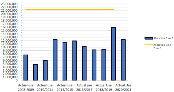
Figure 1 and Figure 2 below show the water used seasonally (able to be aggregated during the season) in the Ruataniwha Basin groundwater zones 2 and 3. While water has been allocated up to the allocation limit this has not been fully utilised in any year. The limit has not been reached in any season. In the 2019/2020 year which was a drought year, extra water was allocated later in the season for use but not to exceed the allocation limit.
Figure 1: Ruataniwha Basin Groundwater Allocation Zone 2 - Groundwater Use (m3/year)
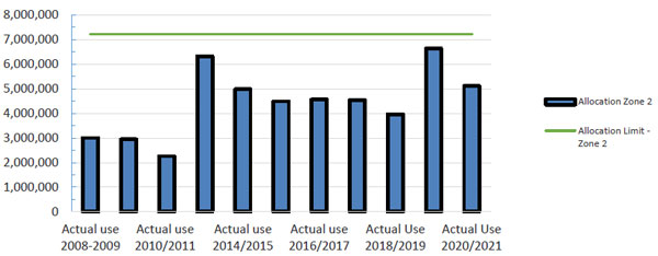
Figure 2: Ruataniwha Basin Groundwater Allocation Zone 3 -Groundwater Use (m3/year)
Council plans have set allocation limits for surface water bodies and groundwater. NPSFM reinforces the need for these. These will be reviewed and reset across the entire region via a new freshwater plan (Kotahi) by 2024 as is required by NPSFM. Water metering data will assist in this process.
SHARING OF INFORMATION
The AG’s report advised that Councils need to share and promote more information with the public about how much freshwater is used.
Council is establishing a water allocation tool to concisely count the amount of water that is allocated from each water management area. This is to be made available online. And it is working towards better reporting of the water that is used. There is reporting up to the national website – LAWA but at this time the water use data is not available. Council’s web site includes information on Good Farming Practice and links to the Water Allocation Calculator (provided by Irrigation NZ).
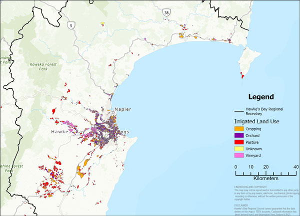
An assessment has been done to identify spatially where irrigation water has been used and the associated land use for the 2019/20 irrigation season. The water metering data collected by Council has been essential to this piece of work.
Further work is now underway to take this from a one-off mapping exercise described below (Attachment 1), to refine the process and make it available through Council Intramaps. Once the systems are in place for joining the various datasets, this mapping can then be replicated on an annual basis. This gives Council an ability to target water management approaches to particular land uses or locations to get the greatest value for effort. Long term it could assist Council in spatially tracking actual water use for plan changes, consent renewals and other planning processes.
ATTACHMENT 1.
MAPPING IRRIGATED LAND USE IN HAWKE’S BAY
An assessment has been done to identify spatially where irrigation water has been used and the associated landuse for the 2019/20 irrigation season. The water metering data collected by Council has been essential to this piece of work.
Further work is now underway to take this from a one-off mapping exercise described below, to refine the process and make it available through COUNCIL Intramaps. Once the systems are in place for joining the various datasets, this mapping can then be replicated on an annual basis. This gives Council an ability to target water management approaches to particular land uses or locations to get the greatest value for effort. Long term it could assist COUNCIL in spatially tracking actual water use for plan changes, consent renewals and other planning processes.
The initial land use and irrigation mapping used the following data and reports:
- National irrigated land spatial dataset: 2020 update (Dark, 2020) which was prepared for Ministry for the Environment;
- Land use data from LCDB, Agribase and local knowledge
- Irrigation Consent information
- Water meter data
The following briefly explains how these layers have been joined for the irrigated land use mapping.
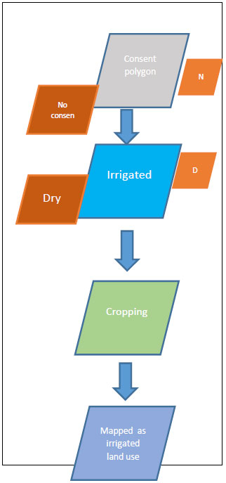 Consent layer/data
- Irrigation consent polygons and points used to ‘trigger’ parcels in land use layer
- Auth ID links water use data to irrigated parcel. Actual consent polygons not used due to inaccuracies of irrigation areas within the polygon.
- Water use from water meter data, proportionally applied to land based on proportion of land use
Irrigation layer (MFE/Aqualinc)
- Aqualinc landuse layer clipped to actual irrigation area. Non irrigated land removed from this layer.
- Aqualinc irrigation mapping has been edited using some local knowledge
Landuse
- Landuse data from LCDB, Agribase and local knowledge have been used
The various data sets have limitations and will need to be refined over time depending on how the output is used. However, it does provide a good basis to understand where and how water is being used in the primary sector. The following table shows the breakdown of water use for the 2019/20 irrigation season.
There are a couple of points to note: Firstly, this was a drought year so irrigation volumes will be influenced by irrigation bans i.e. lack of supply. Secondly, although orchard and vineyard land uses have been mapped separately, the figures have been combined in the table due to uncertainties of the split between these land uses.
| Land Use | Area in Hectares | Percentage of Hectares Total | Water Volume (Mm3) | Percentage of Total Irrigation |
|---|---|---|---|---|
| Cropping | 9940 | 22.97 | 13.5 | 18.54 |
| Pasture | 16159 | 37.34 | 27.9 | 38.31 |
| Orchard & Vineyard | 16679 | 38.54 | 29.8 | 40.92 |
| Unknown | 494 | 1.14 | 0.085 | 0.12 |
| Unmapped (Consented Takes)* | ** | ** | 1.54 | 2.12 |
| Total | 43272 | 100 | 73 | 100 |
Table 1: Hawke’s Bay irrigated land area and water use.
**Unmapped – 10765.85 ha is excluded from further assessment due to unreliability
The following map shows the distribution of land uses that are irrigated in Hawke’s Bay 2019/20.
Further mapping outputs that are currently underway include:
- Irrigation volume for the various parcels of land (total m3 and m3/ha)
- Percentage of consented water take vs actual water use

